Hello, welcome to Nanjing Longce surveying and Mapping Technology Co., Ltd!
语言选择:  ∷
∷ 
∷ ∷
GIS and BIM are located in two different industries. The cross-boundary integration of the two is not an accident, but a "complementary way" in which each takes what it needs and benefits each other. In the industrial application, BIM provides the data basis, while GIS provides the spatial reference.If BIM is regarded as a pearl, it will become an amazing and convenient necklace under the careful connection of 3DGIS.
Based on sufficient information expression, the whole life cycle of buildings, the characteristics of 3 d visualization technology http://www.longce.net, collaborative, BIM revolutionized the way of construction engineering design, construction and operational, after nearly 10 years development, BIM is by "give priority to with modeling" BIM1.0 to "give priority to with multidimensional data applications" BIM2.0 age span, "BIM + GIS" as an important direction of BIM multidimensional application,The professional spatial query and analysis ability provided by GIS and the macro geographical environment foundation have mined the BIM value deeply.In recent years, 3DGIS technology has become increasingly mature. SuperMap 3DGIS, based on the 2-d integration technology system, organically integrates the spatial analysis capability of practical GIS and brilliant 3d visualization effect, providing rich geospatial information for BIM.Based on the cloud integration technology system, SuperMap provides BIM with mature application technology of "cloud + end", which can solve the technical and management problems of BIM under the light weight operation and maintenance scenario.With the support of 3DGIS technology, BIM is integrated with multiple spatial data such as inclined photographic model, terrain, three-dimensional pipeline, etc., to realize the integrated management from outdoor to indoor by complementation of macro and micro.
BIM and 3DGIS perfectly integrate technical solutions
[Convenient import mechanism to solve data docking problem]
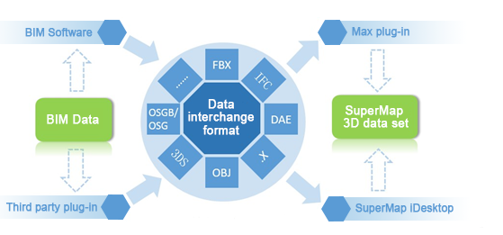
At the data docking level, SuperMap GIS provides a convenient BIM import mechanism, supports the commonly used mainstream BIM data formats (FBX, IFC, Dae.x, OBJ, 3DS, OSGB/OSG), and USES the key field "graph ID" as the medium to ensure one-to-one correspondence between model and attribute. From BIM software to 3D GIS platform, model seamless docking and attribute nondestructive integration can be achieved.
[Platform Performance guaranteed by Instantiation and LOD Technology]
For the sake of performance requirements, SuperMap GIS USES LOD structure and instantiation technology to break through the visibility performance bottleneck of high-density models: LOD technology can select models with different degrees of precision according to the distance, which greatly alleviates the pressure of hill shading.The reuse model is realized by using the instantiation technology, and the rendering efficiency is improved significantly.
[Powerful platform provides many practical functions]
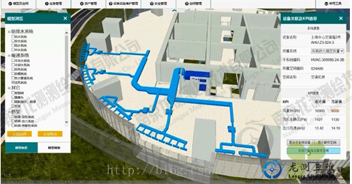
In terms of practical functions, SuperMap GIS provides BIM with general GIS functions such as attribute query statistics, access analysis, sunshine analysis and indoor roaming, etc.Realized the BIM special function of simulating building construction process and specifying floor/component display separately;BIM coordinate transformation and BIM accurate matching with other spatial data are provided, which can meet the application requirements of the perfect combination of large scenes and fine indoor scenes.By comprehensively applying these functions in practical applications and giving full play to the advantages of GIS in location service and spatial analysis, BIM will generate practical and extensive application value.
Adhere to open a win-win concept of cooperation, BIM and 3 dgis cross-border integration market prospect is limited, can be used in urban planning, urban traffic analysis, indoor navigation, asset management, municipal pipe network management, the number of disaster prevention, emergency rescue, building, and many other areas, compared with their own individual application, the modeling, analysis, quality precision, decision-making efficiency, cost control levels have increased significantly.
BIM+ Inclined photography to Promote the construction of smart city
Reviewing the tortuous road of building a smart city, we clearly realize that a single data and technology cannot achieve real smart services. The cornerstone of building a smart city is to realize complete digitization, which must be achieved through the combination of data and technology.With the progress of science and technology, the mature tilt modeling technology makes the tilt photographic model widely used, and its omni-directional and all-essential display of the physical world meets the needs of urban geospatial digitalization.As a fine model with accurate size and detailed information, BIM fills the gap in the micro field and realizes the digitization of urban interior space.
Geographic information as an important information, the basis of intelligent city tilt photography technology scheme based on SuperMap leading the industry, 3 d GIS, puts BIM and tilt model under the same reference, formed from outdoor to indoor, macro to micro integrated geographical spatial scenes, organic combination of BIM and oblique photography model to speed up the pace of the wisdom urban construction, drink set a solid foundation for the spatial information.
[BIM+ 3D Pipeline Construction of complete pipeline management system]
In 3 d digital factory district and municipal pipe network scenario, the earth, and all kinds of underground complex pipe network and equipment quantity is very large, given the unique advantages of BIM technology, design phase usually use BIM technology is comprehensive, three-dimensional pipeline with BIM technology on the scale of construction and mechanical and electrical equipment for real 3 d modeling, a comprehensive collision detection, arbitrary cutting and axonometric, determine a function such as, are helpful for the design and construction.
After the project is completed and put into operation, a THREE-DIMENSIONAL pipeline management system will be built for operation and maintenance management.Based on SuperMap 2-D integration technology system, 3d pipe points, pipeline symbols and adaptive pipe point symbols are adopted for pipeline part to realize rapid construction of 3D pipe network scene.For ancillary buildings and mechanical and electrical equipment, the BIM model established during pipeline synthesis can be directly used.The combination of 3D pipelines and BIM model can quickly build a complete and real 3D pipeline scene. The 3D installation network analysis capability provided by 3DGIS can quickly search the upstream valve to be closed and analyze the affected area in case of pipe pipe explosion.Based on 3DGIS, it provides practical functions such as section inspection, excavation analysis, net distance analysis, collision analysis, connectivity analysis and so on, which can analyze and solve practical problems of pipeline management.
 Sweep WeChat yards pay attention to us

Quotation and presentation requestliuchunlei@longce.net

The mobile phone+86 13851969931
Nanjing Longce Measurement Technology Co., Ltd Address:No.15 Xinghuo Road, Jiangbei new district, Nanjing,China. ICP:苏ICP备20044645号-1